) by Steven Hill and Rebecca Heald, steephill.tv
(The free QuickTime player may be needed to view the movies)

The contrast of the Canterbury flatlands and the remnants of the Lyttelton and Akaroa volcanoes illustrates that cycling in Christchurch could appeal to anyone.
36 photos and movies () by Steven Hill and Rebecca Heald, steephill.tv
(The free QuickTime player may be needed to view the movies)
 |
12 minutes of the best cycling in Christchurch and Banks Peninsula with several helmetcam descent clips, multi-camera editing, and cool hangliding footage. |
According Nature Magazine, the August 15th 2006 aerial photo of Christchurch and Banks Peninsula taken from the International Space Station is one of "most arresting" photos of 2006. Cycling Banks Peninsula is as challenging as it looks. Our Chirstmas day loop from Christchurch through Akaroa featured 12000 feet of climbing in 105 miles with only one of the climbs hitting the 2000 foot elevation mark. No wonder Lonely Planet's Cycling New Zealand(out-of-print) recommends loaded cyclists allow four days for this ride. The weather for our ride started out great and then slowly deteriorated into a thick fog by the end of the day. As the weather deteriorated so did Rebecca's energy. Her health wasn't 100% during the trip and she would later call it the toughest day she's spent on a bike. So our Christmas day ride in Christchurch and Banks Peninsula was up and down in more ways than one.
Last year, we spent a great Christmas cycling on the Big Island of Hawaii. This year we also went Polynesian, traveling to the southern hemisphere and across the International Date line to New Zealand. Both spots offer incredibly diverse landscape among other similarities. As our best travel reference book, The Rough Guide to New Zealand
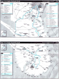
Banks Peninsula Circuit: 105 miles, 12000 ft of climbing
map and route sheet (size: 2.5MB) From downtown Christchurch, take any of the many bike routes to Ferry Road and head east to Banks Peninsula. This portion is very flat as is Christchurch itself. The terrain and rich soil produced by alluvium explains why Christchurch started as a collection of farms. Today, Christchurch is known as The Garden City because of the quality and care residents put into their gardens. There is also a tranquil and beautiful botanical garden in the center of town that is surrounded by the 161 hectare Hagley Park. The flat portion of the ride ends abruptly at Banks Peninsula and level-ground is sparse for the next 70 miles.
I had heard and read great things about Banks Peninsula. It's a mountainous collection of crater rims and cinder cones from the remnants of two, old, steep stratovolcanoes that have now sunk 2500 meters over (a long) time. Both craters eventually flooded forming Lyttelton Harbour and Akaroa Harbour. The peninsula was once an island, but over time alluvium from the Southern Alps extended the mainland shoreline to link up with the once isolated volcanoes.
Whether you take Mt Pleasant Road or the slightly easier Evans Pass Road up to Summit Rd you're in for a good warm up. The route up Mt Pleasant Rd gains 500 m in just 5.5 km. After either climb payback is immediately forthcoming, with a picturesque descent overlooking turquoise Lyttelton Harbour before landing in the historic port town of Lyttelton. For our route, it's a good idea to take the five minute Diamond Harbour Ferry across Lyttelton Harbour. This saves considerable time short-circuiting the long ride around harbour and time is what you need for this ride.
From Diamond Harbour, we rode south along the east side of the peninsula for 1 1/2 hours without seeing a person let alone a car. It was isolated, but it was also Christmas morning. The weather was sunny and the day was warming up nicely. After climbing and descending into Port Levy we encountered the dirt portion of the route and were relieved to find it was mostly hard packed, because it's a steep 5.5 k, 600 m up Wild Cattle Hill. We brought along our sandals in event we had to the get off our bikes and walk until the sealed (paved) road resumed. After climbing through the lush, mostly barren, hills with sheep scattered around, and then descending for another 5 km, we were on the sealed road again at Pigeon Bay where we even saw a few human beings. It's unusual to road bike and not see anyone for almost two hours. Pigeon Bay is a magnificent turquoise color and a good spot for eating our packed lunch. Without much time to digest it we were dancing out of the saddle up Pigeon Bay Road for another 6 km up to the rim of the Akaroa crater.
After shooting more helmetcam footage on the scenic descent to Akaroa Harbour, we were fortunate to find a restaurant in Duvauchelle that was open for a few hours, serving their hotel guests a Christmas lunch. We didn't eat there, but they graciously filled up our near empty water bottles. Duvauchelle is indeed French. Adjacent Akaroa is not only the South Island's oldest colonial town, it's also New Zealand's sole French Settlement. Apparently, France had plans on colonizing New Zealand or at least the South Island, but the British beat them to it. The initial French settlers decided to stay even though they were governed by the British. For us, Akaroa was the halfway point of our difficult ride. We snacked on bananas and energy bars by the beautiful, quiet harbour knowing another tough 6 km climb was just ahead to climb back out of the crater.
The route to Cabstand on Long Bay Rd was not only the highest (630 m) and steepest (average 12%) climb of the day, it was also into a stiff wind. All things considered, we both agreed it was the hardest 5 km climb we had ever done. Every time I stood, I felt the wind trying to push me down the hill. We have some quality footage of us crawling to the top on our hands and knees. Rebecca never recovered after that climb and with the fog rolling in the rest of the ride would become increasingly difficult for her even though the toughest climbing was over.
If it weren't for the fog I might be raving about the 360 degree view as one bobs and weaves along the ridge (Summit Rd) formed by the volcano crater rim with the harbor on one side and the Pacific Ocean on the other. For those interested in breaking this ride into two days, the Backpackers Hostel at Le Bons Bays comes highly recommended by others. They were booked through the beginning of January when I called them in mid-December.

The roller-coaster ridge ride ends where Summit Road meets with the two-lane highway, SH75. From there, it's a descent to Little River followed by 30 km of flat cycling along the shores of Lake Ellesmere. We discussed aborting the last climb having notched enough climbs and rationed our food. But when I made the call to finish the route as plan via Cobbler Knob (573 m) Rebecca didn't object.
The fog was now very thick similar to what often rolls into San Francisco Bay. We battled up the final climb in wet, windy conditions and thought we'd eventually descend out of the fog, but Christchurch, at sea-level, wasn't low enough on this day.
This was a challenging Christmas day route, with most of the elevation gain in six steep climbs each around 6 km, each at 8 to 12% grade. It's a terrific ride and a Top 10 in my books, but may be more enjoyable if spread out over two days. — Steve, January 18th, 2007
Next Report... The Lupins, “Rock Flour” and Helmetcam descent at Lake Tekapo »
Related Info
Le Race: The annual 100 km race from Christchurch to Akoroa - Saturday, March 28th 2009
Map and Route Sheet for this Banks Peninsula ride
Cyclists dodge rocky death (on Evans Pass) — stuff.co.nz
(Added: Feb 23/2011)

| « steephill.tv home page | • | Report 2: The Lupins, “Rock Flour” and Helmetcam descent at Lake Tekapo » | • |